The “Integrated Biostratigraphic & Lithostratigraphic Framework of Offshore Ireland” project, which was awarded by the Petroleum Infrastructure Programme (PIP) to a Merlin led consortium in 2016, is currently in its final write up stage. The main report document comprises an Atlas, which will contain detailed descriptions of the newly defined lithostratigraphy, chronostratigraphy, sequence stratigraphy and biostratigraphy, copiously illustrated with maps, well displays and numerous seismic lines. Upon completion, the bulk of the Atlas will be made publicly available. The PAD (Petroleum Affairs Division) also plans to use the work as the basis of a special publication documenting the new stratigraphy.
The project received a high profile at the Atlantic Ireland 2019 Conference held in Dublin in late October, where some of the key results were presented in three conference talks. The first talk, by Mischa Gehlen of IGI, in collaboration with Philip Copestake of Merlin and Paul Farrimond of IGI, presented the results of the assessment of all source rock intervals for the offshore Ireland area, placed into the new stratigraphy defined by the project. 21 formations with varying source potential have been identified (see below).
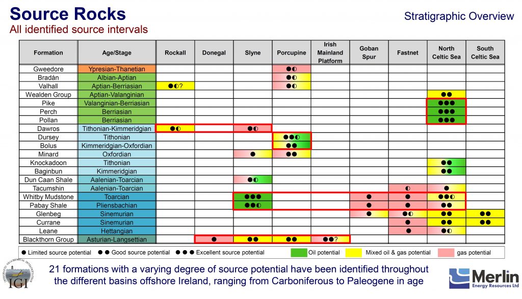
Excellent oil source potential has been identified in the Pliensbachian Pabay Shale and Toarcian Whitby Mudstone in the Slyne Basin and mixed oil and gas potential in the North Celtic Sea Basin. Excellent oil source potential is demonstrated for the Purbeck Group in the North Celtic Sea Basin. Other source intervals of note include the Sinemurian and Upper Jurassic of the Celtic Sea area, the Carboniferous and the Upper Jurassic of the Porcupine Basin.
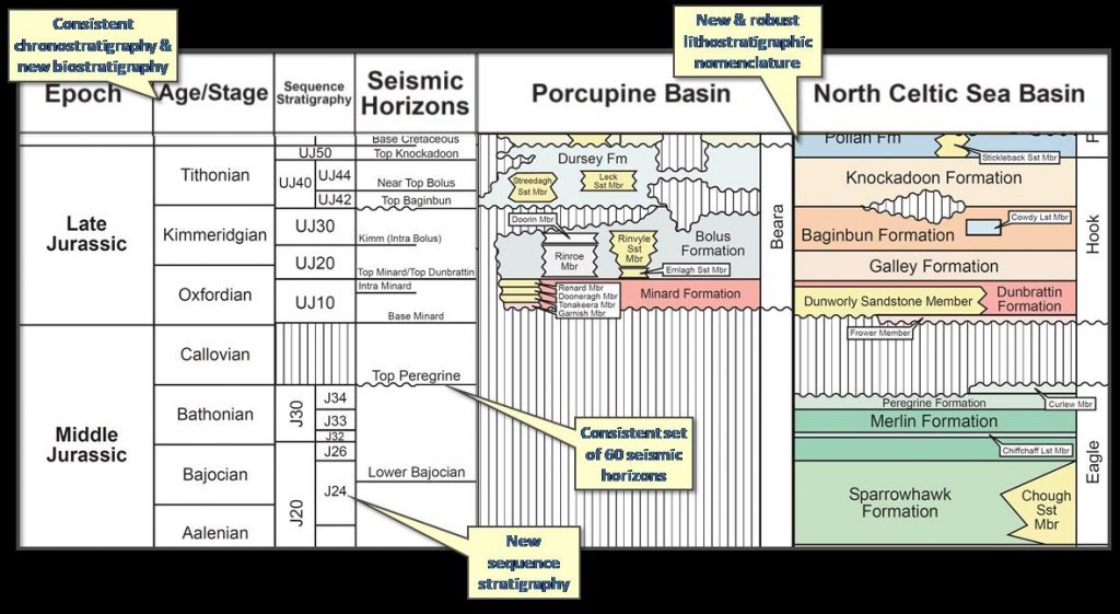
The second presentation, by Tim Wright and Philip Copestake of Merlin, discussed the significance of the project results for hydrocarbon exploration within offshore Ireland and internationally. An overview of the project scope and contents is shown below, for the Middle and Upper Jurassic of Porcupine Basin and the North Celtic Sea Basin.
There is now a need to use the results to better understand prospectivity in the area by improved knowledge of reservoir distribution (away from proven well locations) and to map defined source rock intervals to accurately define source kitchen locations. The new stratigraphy will also help significantly in understanding tectonic evolution of the region, which, tied to basin modelling and sequence stratigraphy, will provide the foundation for a new understanding of timing of phases of faulting and trap creation, source rock maturation and hydrocarbon migration. It will also now be important to use the new information to better understand the evolution of the wider North Atlantic Conjugate Margin by detailed correlations with Eastern Canada and other countries.
The third presentation based on the study was by Pat Shannon, in collaboration with Mick Hanrahan and Kara English, who outlined the new lithostratigraphic nomenclature scheme and the philosophy behind the naming themes (see above diagrams for some examples).
If you wish to learn more, please feel free to contact us.
