
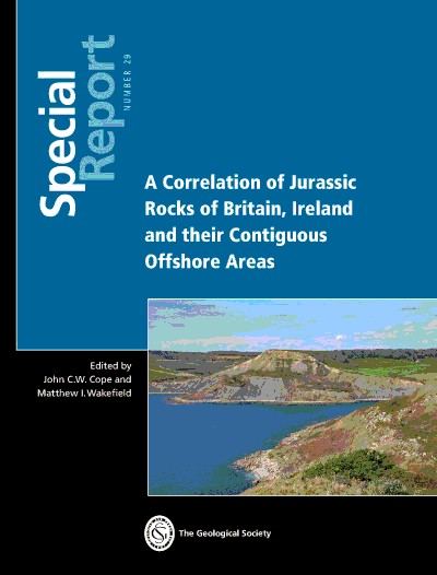
This week marks the publication of a major new reference work on the Jurassic geology of Britain, Ireland and their contiguous offshore regions, published by the Geological Society of London. The volume represents the most comprehensive synthesis of Jurassic stratigraphy across the region for more than four decades and includes significant contributions from Merlin staff.
Our Principal Geologist and Stratigrapher, Philip Copestake, is co-author of the book’s largest chapter, which documents the offshore development of Jurassic rocks across more than 60 sedimentary basins surrounding the British Isles. The study extends beyond the UK and Ireland to include neighbouring offshore areas of France, Denmark and Norway, providing the first unified synthesis of Jurassic geology across these offshore regions.
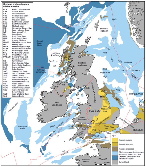
Figure 1 illustrates the distribution of Jurassic basins around the British Isles. Many of these offshore basins are extensions of well-known onshore geological provinces, including the Wessex Basin, exposed along the UNESCO-listed Jurassic Coast of Dorset and Devon, and the Cleveland Basin, famous for its Jurassic exposures along the Yorkshire coast.
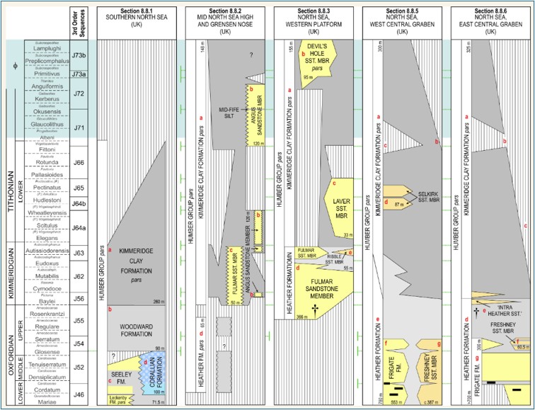
The publication is built around an extensive series of correlation charts comprising 207 onshore and 85 offshore lithostratigraphic columns. Each column represents a specific depositional basin or region and provides both a summary of local stratigraphy and a gateway to more detailed geological information. Figure 2 shows an example correlation chart from the Southern North Sea and Central Graben.
Bringing Together Decades of Knowledge
The offshore chapter draws on several important developments in recent years. These include the release of substantial subsurface datasets by the North Sea Transition Authority through the National Data Repository, together with a comprehensive re-evaluation of offshore Irish Jurassic stratigraphy undertaken by a Merlin-led consortium for the Irish Government (Merlin, 2020). Read our newsletter from November 2020 to find out more about this project, or click the following link to go to the Irish Government website where you can download The Standard Stratigraphic Nomenclature of Ireland report and digital addenda.
Combining these newly available datasets with decades of industry experience, the chapter’s authors, Nigel Ainsworth, Philip Copestake and Matt Wakefield, have produced a significant new synthesis of Jurassic geology in the region. Georgina Lockham, also from Merlin, contributed by compiling a comprehensive map of North Sea wells known to penetrate Jurassic strata, amounting to 3808 wells in total.
Building on a Classic Geological Reference
The new volume was originally conceived as an update to the pioneering Jurassic correlation books published in 1980 by the Geological Society of London (Cope et al., 1980a, 1980b). However, the dramatic advances in geological understanding over the intervening decades, particularly those driven by offshore hydrocarbon exploration and development, have resulted in significantly enhanced understanding of Jurassic rocks.
Reflecting on the publication, Philip Copestake said:
“I have been fortunate to be involved in the hydrocarbon industry of the North Sea and onshore UK since its initial exploration in the early 1980s and have seen the information and knowledge of the area advance hugely over that time. I have witnessed many ups and downs in the industry and have been able to contribute to the increased knowledge of the Jurassic through my own work with a number of companies such as Britoil, BP, IEDS and Merlin, combined with my own personal research, in collaboration with many friends and colleagues. I am grateful for the opportunity to participate in this landmark book documenting our latest knowledge of the Jurassic of the region. It is immensely satisfying to see the publication of this book after so many years (nearly 30) in gestation, and I also feel privileged to be sharing authorship with a group of known experts on the Jurassic System. I thank Merlin for supporting this work and to our client companies, for whom I continue to carry out fascinating studies of Jurassic reservoir and source rocks, which continue to be explored for new reserves of hydrocarbons in this world class resource basin. I am particularly thankful to several Norwegian exploration companies who are applying my work and involving me in their exploration of the Jurassic. I hope that this publication, together with my other contributions, will help them in this quest.”
Continuing Jurassic Research
Philip’s work on the Jurassic is far from over. Current projects include research associated with the Fossil Fishing at the Farm excavation at King’s Stanley, Gloucestershire, in summer 2026, studies of Jurassic stratigraphy in Mid Norway, micropalaeontological sampling along the Dorset Jurassic Coast, and collaboration with the Berriasian GSSP Working Group of the Subcommission on Cretaceous Stratigraphy, which is working towards defining the internationally recognised Jurassic-Cretaceous boundary, a topic discussed in the new volume.
We look forward to sharing updates on these and other Jurassic research projects in future newsletters.
Further Information
The new publication, A Correlation of Jurassic Rocks of Britain, Ireland and their Contiguous Offshore Areas, The Geological Society Special Report 29 is currently available in electronic format via the Geological Society.
Individual chapters can also be downloaded separately through the Society’s online publications platform.
A printed edition is expected to be available from the Society’s bookshop shortly.
Merlin is grateful to the Geological Society of London for permission to reproduce figures from this important new publication in our newsletter.
References
Cope, J.C.W. (ed.) 1980a. A Correlation of Jurassic Rocks in the British Isles. Part 1. Introduction and Lower Jurassic. Geological Society, London, Special Reports, 14.
Cope, J.C.W. (ed.) 1980b. A Correlation of Jurassic Rocks in the British Isles, Part Two: Middle and Upper Jurassic. Geological Society, London, Special Reports, 15.
MERLIN ENERGY RESOURCES CONSORTIUM. 2020. The Standard Stratigraphic Nomenclature of Offshore Ireland: An Integrated Lithostratigraphic, Biostratigraphic and Sequence Stratigraphic Framework. Project Atlas. Petroleum Affairs Division, Department of Communications, Climate Action & Environment, Special Publication 1/21.