In the dynamic world of subsurface engineering, the synergy between geoscientists and reservoir engineers is nothing short of transformative. Following on from the first blog in the series, this second blog delves into how geoscientific insights serve as the driving force behind reservoir engineering decisions, ultimately maximising the potential of energy reserves.
The Geoscientific Blueprint: Guiding Reservoir Engineering
Geoscientific data forms the bedrock upon which reservoir engineering strategies are built. Here’s how geoscience insights empower the engineering process:
Stratigraphic Understanding
Geological analysis unveils the intricate layers of rock formations that hold energy resources or could hold energy generation by products. This understanding guides the selection of zones of interest and informs well placement strategies.
Porosity and Permeability Assessment
Petrophysical data provides crucial information about the porosity and permeability of rock formations. These properties dictate the flow of fluids within a rock unit, influencing production or injection strategies and resource estimates.
Fault and Fracture Analysis
Structural geology enables identification and characterisation of faults, fractures, and other features. This knowledge is indispensable for reservoir engineers in designing well architectures that bypass obstructions and maximise resources.
Real World Impact: Case Studies in Synergy
The marriage of geoscientific insights with reservoir engineering expertise has yielded remarkable results in real-world projects. Here are a few examples:
Case Study 1: Maximising Recovery in a Western Siberia Field
By establishing a thorough understanding of the evolving regional depositional system of the Jurassic, and incorporating the geoscientific field data, a robust understanding of the field’s reservoir geology was derived. Combining this model with dynamic data points allowed for the identification of a previously unidentified thief zone. The incorporation of this thief zone into the simulation model, by our partner Belltree, resulted in a better understanding of the connected fluid pathways within the field, and enabled a successful history match to be made.
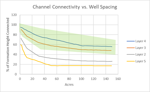
Theoretical models from literature, relating sand body height and width, were evaluated to identify the most appropriate sedimentological model for the field. Measurements of all sand body heights in the field were then conducted, and widths estimated. By determining average well spacing for each formation, it was possible to calculate the percentage of connected net height. Findings from this work highlighted that placing injectors in layers 3 and 4 of the field would be most beneficial, as those formations were likely to have a high degree of inter-well connectivity within the sand. These conclusions were supported by a surveillance connectivity review.
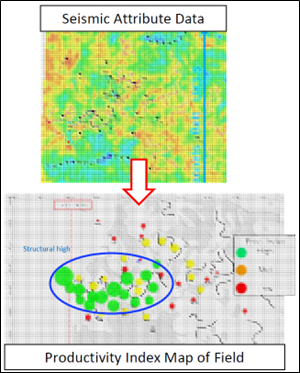
The analytical surveillance review also indicated a significant correlation between structural elements (crestal opening of fractures) and deposition patterns (east-west channelization), with well productivity. Our study enabled the targeting of future wells, through generation of an understanding of geological properties away from well control points by incorporating both geological attribute maps and traditional reservoir engineering maps.
Utilising the work carried out, the client went on to drill both production and water injection wells improving the recovery of the field by 20%. Water injectors were focused on the formations likely to have a high degree of inter-well connectivity between the sands, thereby maximising their impact.
Case Study 2: Locate the Remaining oil Southeast Asia Mature Water Flood Field
Merlin, in collaboration with our partner Belltree, conducted an in-depth review of a complex Southeast Asian field that had significant compartmentalisation and two decades of production history.
The field data was systematically organised based on the 12 fault blocks and 60 reservoir pools present. The assessment of underdeveloped compartments was then facilitated through comprehensive benchmarking analysis against analogous reservoirs. Asset maps and cross sections were meticulously generated, providing a visual representation of current saturations and pertinent production-related observations. Through a thorough examination of dynamic and seismic data, our collaborative effort advocated for a revised fault connectivity model. This new model identified several underperforming depletion drive compartments, revealing a potential incremental resource of 86 million barrels.
Merlin’s integrated Approach: Where geoscience meets engineering
Merlin has proven time and time again through our project work the significant role that geoscientific insights play in driving reservoir engineering decisions. Our technical team have adopted a synergistic approach to allow the full potential of energy resources to be unlocked, thereby driving sustainable energy solutions. Stay tuned for our next blog where we explore how reservoir engineering analysis combines with geoscientific interpretations.

