We are very pleased to announce that the comprehensive report on the stratigraphy of offshore Ireland, completed in 2020 by a Merlin led consortium of companies, has now been released publicly as a special report by the Irish Government.
MERLIN ENERGY RESOURCES CONSORTIUM. 2020. The Standard Stratigraphic Nomenclature of Offshore Ireland: An Integrated Lithostratigraphic, Biostratigraphic and Sequence Stratigraphic Framework. Project Atlas. Petroleum Affairs Division, Department of Communications, Climate Action & Environment, Special Publication 1/21.
The study was commissioned by the Irish Shelf Petroleum Studies Group (ISPSG) of the Petroleum Infrastructure Programme (PIP), with the aim to establish a new stratigraphic framework for all future subsurface evaluations, both academic and commercial, including CCUS projects. The project presents new lithostratigraphic, chronostratigraphic, biostratigraphic and sequence stratigraphic frameworks for the Ireland offshore region. These are based on an extensive legacy data set of 264 wells and boreholes and published research, supplemented by a significant amount of new data generation and interpretation.
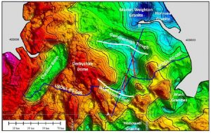
The project has been carried out by a consortium of companies, led by Merlin Energy Resources Ltd, also incorporating Palaeodate Ltd, Network Stratigraphic Consulting Ltd, Riley Geoscience Ltd, and Integrated Geochemical Interpretation Ltd. The study area includes the Rockall, Slyne, Erris, Donegal, Macdara/Bróna, Porcupine, Clare, Goban Spur, Fastnet, North Celtic Sea, South Celtic Sea, Kish Bank and Central Irish Sea basins of the offshore Ireland region.
The study defines 309 lithostratigraphic units (groups, formation, members and units) and provides maps showing their interpreted distributions as well as summary logs for 197 of the wells and boreholes. New sequence stratigraphic schemes are defined for the Triassic-Quaternary interval and new biozonation schemes for the Jurassic – Cenozoic section. The resulting stratigraphy has been compared to adjacent regions of Eastern Canada, the UK Continental shelf and the North Sea to understand the more regional context.
In addition to the well data 60 seismic horizons have been identified, and are illustrated in numerous seismic sections within the report. These have been combined with gravity data to revise the structural elements of Offshore Ireland which includes a new definition for the boundary between the Fastnet and North-Celtic Sea Basins.
The new lithostratigraphy, chronostratigraphy and sequence stratigraphy schemes are summarised in a large scale Regional Chronostratigraphic Summary Chart.
To quote Clare Morgan, Head of Technical Services, Department of Communications, Climate Action and Environment, “The project has generated a quality document of tremendous importance to the geoscience community……….This illustrative deliverable provides a reference tool for all geoscientists whether industry, researchers or government based, and this unique document will be utilised for many years and decades into the future.”
In addition to the Merlin report, the Special Publication “The Stratigraphic Nomenclature of the Irish Offshore Basins” is also available on the gov.ie website, which explains the rationale behind the lithostratigraphic naming scheme that was applied in the Merlin report.
Further details regarding the content of the atlas are provided below.
The reservoir intervals for all producing gas fields and discoveries in offshore Ireland have been placed into the new lithostratigraphic nomenclature (see Atlas Introduction, Section A). All test intervals have been incorporated into the project and are plotted against the new stratigraphy on the supplied project well and borehole summary logs provided as a digital Appendix (Atlas Appendix C). The new Ireland stratigraphy has been compared to adjacent regions of offshore East Canada, the UK Continental Shelf and the North Sea. This is illustrated in a series of stratigraphic charts included in the Atlas (Section C, Stratigraphic Columns). This will help advance the understanding of the geological evolution of the wider North Atlantic region.
A set of 197 well and borehole stratigraphic summary logs is provided in pdf form, as a digital appendix to this atlas, Appendix C; Summary well/Borehole Logs. Lithostratigraphic tops for all wells and boreholes are provided in a spreadsheet listing; see Digital Addenda.
Detailed descriptions of lithostratigraphy, chronostratigraphy and sequence stratigraphy, including source rock intervals, are provided in the Atlas Sections D1-D10, covering the Precambrian to Cenozoic intervals. This section includes definitions for all the recognised stratigraphic units for offshore Ireland.
Stratigraphic sequences have been recognised and defined from interpretations of well and seismic data, over the Triassic-Quaternary interval. New sequence stratigraphic schemes are defined and described for most of these intervals and are integrated and compared with previously documented schemes for the region. Existing schemes are utilised for parts of the Jurassic and Cretaceous intervals. These schemes are described in the individual stratigraphic chapters in the Atlas (Stratigraphic Summaries, D.5-D10).
Appendix B of the Atlas defines new biozonation schemes for the Jurassic, Cretaceous and Cenozoic of the offshore area, based on a thorough review of all legacy data with new analysis of over 3000 samples from 106 wells. For the Carboniferous and Triassic, existing published palynology biozonation schemes have been applied.
Well interpretations have been tied to an extensive seismic database. Around 60 significant seismic horizons were interpreted and are shown on 10 key regional seismic lines to illustrate the regional stratigraphy and structural development (Section E, Regional Seismic Lines).
A regional evaluation of the source rock potential for offshore Ireland has identified 21 formations with hydrocarbon generation potential based on the newly developed stratigraphy of this project. This is summarised in section B, Geochemistry, supported by further data in Appendix E, Geochemistry.
Intrusive and extrusive volcanic rocks occur throughout the offshore Ireland area, at many stratigraphic levels. Radiometric dating was carried out on selected igneous units, as described in Appendix D, Radiometric Dating. Several of the lavas have also been tied to seismic and available biostratigraphy, resulting in a new understanding of their age and extent.
